
By Micah Mackay
Music: Piano arrangement of ‘He Who Would Valiant Be – Monk’s Gate’ by Toby Nelms
We arrived in the village of Little Bredy to the sound of the church bell bringing in the tenth hour of morning. Having not heard church bells since February this sound instantly brought me back to Oxford and how every Sunday I would open my window and be greeted by a chorus of bells, singing out across the city. The sound of that solitary bell in the middle of a small, remote Dorset village encouraged me. It was a good start.
We took some time to explore the church, St Michael and All Angels, which sits alongside the Bridehead estate. Unfortunately, we couldn’t venture inside but from the outside we were still able to admire the fourteenth-century tower and some intricate later stonework. This included a rather lovely lion’s head, a pipe poking out from its mouth in imitation of a tongue.

Leaving Little Bredy we headed out towards the fields and the Valley of Stones, a National Nature Reserve. Despite being raised on a farm there was some initial reluctance from Mother Mackay to venture into a field with a herd of longhorns. However, a sign attached to the gate reassured her that they were friendly and not particularly inclined to violence, so we continued on. The Dorset countryside soon opened out before us. The Valley of Stones gets its name from the sarsen stones which tumbled down into the valley after the last ice age. Some of these stones were then used in local Neolithic sites, including many of the stone circles we came across during this pilgrimage. Wildflowers abound in the area around these stones and we were soon surrounded by birds, butterflies and the sound of insects in the high grass. Being a geographer, Mother Mackay was, of course, very taken by the landscape and lots of photos of the stones were taken to show her schoolchildren in their online lessons.


Picture 2 – 6: The Valley of Stones
Arriving at the end of the Valley of Stones we ran into a slight issue – the gate we were supposed to go through had been tied shut with barbed wire, making sure that no wayfarer, pilgrim or walker could cross into the next field. I was rather disappointed by this, as in the next field was a ruin that I wanted to explore. The structure in question is marked on the British Pilgrimage Trust website as a ‘Barn or a Chapel.’ However, if you look at the aerial shot from the BPT website the structure is cruciform.


Screenshot taken from: https://britishpilgrimage.org/portfolio/south-dorset-old-stones-way/
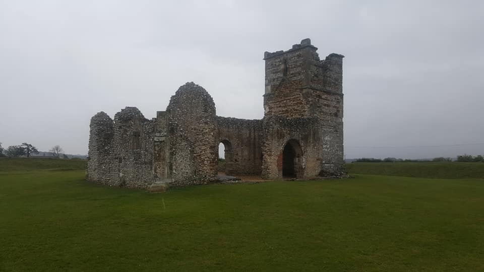
Considering this, and the fact that it is built so near Neolithic structures, I’m inclined to think that the building was probably, at some point, a chapel. It is fairly common for churches and chapels to be found near or, in fact, on top of Neolithic monuments. Take Knowlton Church in Dorset as an example. The church sits in the middle of a circular henge. Placing churches in the middle of henges or near pagan ceremonial sites demonstrates an attempt to ‘re-contextualise’ non-Christian sites within a new, Christian framework. In a sense it is one religion or culture’s attempt to assert itself above another. As such, with the proximity of the structure to Neolithic monuments and bearing in minds the ruin’s shape, I would hazard a guess that this ruin was probably a chapel that, for some reason, fell into ruin. Perhaps it was used for storage or to shelter animals once it had fallen out of use. This could be a reason for it being dubbed a ‘barn’. Reluctant to listen to anymore of me going on about why the ruin might be a chapel, Father Mackay began our detour up towards the top of the ridge, where we hoped we’d find a different gate to lead us onto the road. This time we were in luck. The gate at the top of the ridge was not bolted shut and we could continue our journey to Abbotsbury.

The sun decided to make an appearance as we walked down the road and towards the Kingston Russell Stone Circle. Coats were quickly abandoned and hats were put on instead. The Kingston Russell Stone Circle is a late Neolithic/early Bronze Age stone circle comprised of eighteen of the same sarsen stones found in the Valley of Stones. It is the largest stone circle in Dorset. Sadly all of the stones have now fallen, although there is some debate as to whether some were still standing as late as the 19th century. This area is rich in Neolithic sites – from the Circle to nearby barrows. For example, near to the Circle one can also find a long barrow and burial chamber, known as the Grey Mare and Her Colts. A bowl barrow, one of the most common forms of burial mound, is also a short distance away and makes for quite a prominent landscape feature. The number of these ceremonial and burial sites within this area suggest that this part of Dorset was a site of significant ritual importance. Looking across the hills at the rolling countryside and, past that, the sea, one can definitely see why people may have been drawn to this place from the earliest times and why they may have chosen to bury their dead in such a place.
Leaving the Neolithic and Bronze Age sites we headed towards the medieval. Our path took us across fields, up a rather steep hill (I was crowned Mother and Father’s least favourite child at this point) and then down into the much-needed shade of a small, wooded area above Abbotsbury. Having previously visited the ruins of St Luke’s Chapel, which lie hidden at the heart of the woodland, I knew just what a treat we were in for. The west end of the chapel is all that remains of this Cistercian site. The wall emerges from the surrounding woodland gently and it almost takes your eyes a moment to adjust in order to make out the arch from the surrounding greenery. Ivy has grown over parts of the stone giving the impression of nature reclaiming this space as its own. “It’s like a fairyland!” exclaimed a fellow pilgrim and I would have to agree that this is as accurate a description as any.

St Luke’s is so far removed from the ‘outside world’, that the complexities and troubles of life do not seem able to penetrate the air around it. A visit to this place offers the chance for contemplation, for peace and for removal from all outside influences. This is probably something the small community of monks from Netley Abbey, who resided here, would have relished. It is no wonder that William of Litton, who gave the land used for St Luke’s to Netley Abbey in 1246, wanted prayers said for him perpetually in this chapel.

We stopped for lunch at St Luke’s and I took some time to explore the chapel, taking note of the two carved heads on the inside of the west wall. I also had a closer look at the altar which was constructed at a later point by the Milne-Wilsons, previous owners of the Ashley Chase estate up the road. The Milne-Watsons loved St Luke’s so much that they paid for its conservation and both David Milne-Wilson and Olga Milne-Wilson are buried within the chapel grounds.

Feeling restored, both spiritually and physically, we resumed our journey, with both the parents relieved to see Abbotsbury come into view from the top of the Hardy Way. The weather had turned slightly colder and coats were soon put on again. The section of the Hardy Way near Abbotsbury is quite high up and, as such, the wind was a bit of an issue (I nearly lost my hat!). However, we persevered with coats done up and hats secured. On one side of us the coast stretched out all the way to Weymouth, where we could see the dark shadows of cruise ships lined up in the harbour. On the other side of the Hardy Way was the English countryside in all its green glory. The view could only be described as spectacular and, had the weather been a bit warmer this point, I would have filmed much more of it!

Father Mackay once again set the pace, eager to get out of the wind. A chapel on a distant hill soon came into view – St Catherine’s Chapel, our end goal. We were all starting to feel the tiredness set in as we came down into Abbotsbury and Mother Mackay was not enthused to learn that our final destination involved a trek up another hill.
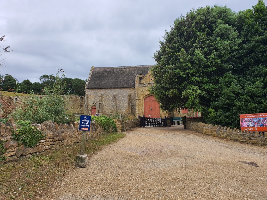
We made our way through the streets of the village, taking in the remains of St Peter’s Abbey, a Benedictine Abbey. The Abbotsbury Swannery was a source of income for the monks who resided here and the Abbey was apparently known for lavish banquets, which often featured swan on the menu. All that remains of the Abbey is the wall of what might have been the Abbot’s lodgings and a few other outlying buildings, including the remains of a huge tithe barn, now part of Abbotsbury Children’s Farm.


We continued on the path towards St Catherine’s, the fourteenth-century hilltop chapel named after St Catherine of Alexandria, patron saint of unmarried women. Apparently, up until the nineteenth-century women would come to the chapel to pray to St Catherine for a husband. The position of the chapel on a hill just outside of the village emphasises the story of St Catherine, whose body was said to have been taken by angels to the top of Mount Sinai following her martyrdom. The hill is steep but on the way up there are incredible views of Abbotsbury, the coast, and the countryside. Walking up this hill I briefly wondered how many pilgrims had walked this very same path. The chapel was, after all, a pilgrimage chapel in the fourteenth-century. Monks would have come from the local Abbey to ‘retreat’ from the world. Although St Peter’s Abbey is not far from the chapel the walk, in itself, would have still been a sort of ‘spiritual journey’, climbing from the bottom to the chapel and, once at the summit, being able to look out over vast expanses of land and sea. Standing near the chapel there is certainly a sense of the ‘immensity’ of creation and one is reminded of the beauty that surrounds us which we often take for granted. The chapel itself even seems quite tall and, as English Heritage notes, must have been incredibly impressive during the medieval period when its windows were filled with stained glass and details on its roof were highlighted in bright colours. St Catherine’s Chapel, in its lonely hilltop position, with its bird’s-eye view over the land and imposing architecture, seems to almost be a stone link between Earth, man and God.
I spent some time at St Catherine’s looking over the sea. This is probably why the building escaped destruction during the Reformation – it holds a strategic position looking out over the ocean and also provides a good view further inland. It felt right to finish the first pilgrimage at the top of a hill and at such a gorgeous historical place. It was a reminder that not every journey is easy but the end result can be truly beautiful and surprising if you persevere. As Becca once said to me, “things turn out best for the people who make the best of the way things turn out.”

This pilgrimage challenge is done in memory of Becca Henderson.
To find out more about the pilgrimage challenge please visit: https://www.justgiving.com/fundraising/micah-pilgrimage-challenge
Any donations/shares of the link are very much appreciated. It all goes a long way to helping support the work of the Royal Brompton and Harefield Hospitals Charity.
